tongariro alpine crossing |
|
|
track information
The Tongariro Alpine Crossing is an alpine trek over steep volcanic terrain and a reasonable level of fitness is required. Times given are an approximate guide as everyone walks at a different pace. The time taken on each section of the track will also depend on rest and sightseeing stops. The amount of climbing required is minimised if the crossing is begun at the Mangatepopo Valley. The track can be walked in the reverse direction but this requires more climbing. Allow an extra hour.
Mangatepopo Valley to Soda Springs (1 to 1 1/2 hours)
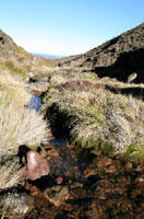
Note the different colours on the lava flows as you walk up the valley. The surface colour of younger lava is darker and absorbs much of the suns heat - this is a harsh environment for plants to grow and the reason why the youngest flows only have a few plants, lichens and moss. The older flows have progressively more species and large plants, which take advantage of the slow build up of precious soil. The vegetation has also been modified by fire and farming. Soda Springs (top of Mangatepopo Valley) to South Crater (40 mins to 1 hour)
South Crater to Red Crater (1 hour)To continue over the Crossing follow the poled route across the South Crater to a ridge leading up to Red Crater.
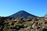
Looking into Red Crater notice the unusual formation within, known as a dike. This feature was formed as molten magma moved to the surface through a vertical channel in the crater wall. Having solidified at its outer surface the dike was later left partially hollow when the magma drained from below. Being more resistant than the surrounding scoria, erosion by wind and rain has now left this structure exposed. The red colour is from high temperature oxidation of iron in the rock. Lava flows from Red Crater extended into Oturere Valley, South and Central craters. From here a side trip can be taken to the summit of Mt Tongariro.
Red Crater to Emerald Lakes (10 to 20 mins)The summit of Red Crater (1886 m) is the highest point on the Tongariro Crossing. From here the track descends steeply to three water-filled explosion craters called Emerald Lakes. Minerals leaching from the adjoining thermal area cause their brilliant colour. The Maori name is Ngarotopounamu meaning greenstone-hued lakes. These lakes freeze in winter. Emerald Lakes to Ketetahi Hut (1 to 1 1/2 hours)The track to Oturere Hut branches off to the right at the lowest lake while the Tongariro Crossing continues over Central Crater (a drainage basin rather than a crater) to Te Wai-whakaata-o-te-Rangihiroa (Blue Lake). Te Wai-whakaata-o-te Rangihiroa translates as Rangihiroa's mirror. Te Rangihiroa was the son of local chief Pakaurangi, Te Maari (after whom the crater is named) was his sister. Te Rangihiroa is said to have explored the Tongariro volcanoes about AD 1750. The lake is tapu (sacred). Do not swim in or eat food around the lake. From Te Wai-whakaata-o-te-Rangihiroa the track sidles around the flanks of North Crater (a cooled lava lake) and descends to Ketetahi Hut. To protect the fragile soil and plants it is important that you stay on the formed track. Ketetahi Hut to Ketetahi Carpark (2 hours)Note the stream from Ketetahi Springs. The acid sulphate water is high in boric acid and some springs are high in ammonia. They also contain magnesium, calcium and iron. The colours in the rocks are from mineral deposits from the water and from hot acid water cooking the rock, also from the red and blue/green algae that grows in the water. The temperatures range from 74°C to 91°C. The temperature of steam from the hottest fumarole (steam vent) is 138°C. The track continues to descend through tussock slopes to the forest bushline. The cool podocarp-hardwood forest provides a final contrast on the long descent to the roadend. At two points the track passes over the tongue of a lava flow from- Te Maari Crater and for a distance follows alongside the Manga-a-te-tipua Stream (polluted with minerals from Ketetahi Springs). Towards the end of the track a short path takes you to a lookout over a waterfall. |
|||||
|
||||||
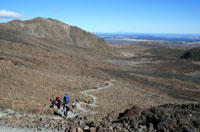
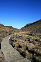
 From the car park at the Mangatepopo Road end, 7 km off SH 47, the track makes its way up the Mangatepopo Valley. Twenty minutes from the carpark a side track leads to Mangatepopo Hut. Continuing at a gentle gradient the main track climbs alongside a stream and around the edges of old lava flows. It is generally believed that the Mangatepopo Valley was glacially carved out during the last ice age and subsequently partially in-filled by lava flows from Ngauruhoe.
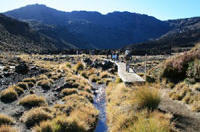 The steep climb from the valley to Mangatepopo Saddle between Mounts Ngauruhoe and Tongariro is rewarded by views of Mt Tongariro and on a clear day, Mt Taranaki to the west. At the top of the climb the
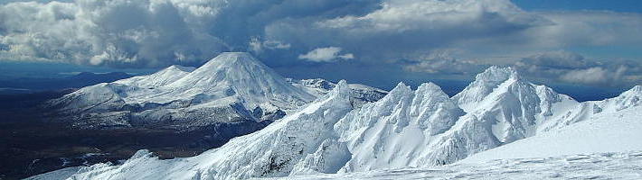
 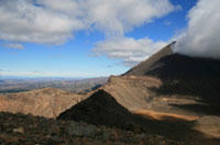 South Crater is not a real crater but a basin that may have been glacially carved and has since filled with sediment from surrounding ridges. An explosion pit in the southeast part of the crater formed around 14,000 years ago. The lava seen from Ngauruhoe dates to the 1870 eruption. As you walk up the ridge to Red Crater you may smell sulphur, evidence that the crater is still active. Enjoy the spectacular view to the east over the Kaimanawa Forest Park and Desert Road.